Tobacco-Free, Smoke-Free, Vapor-Free Campus Boundary Map
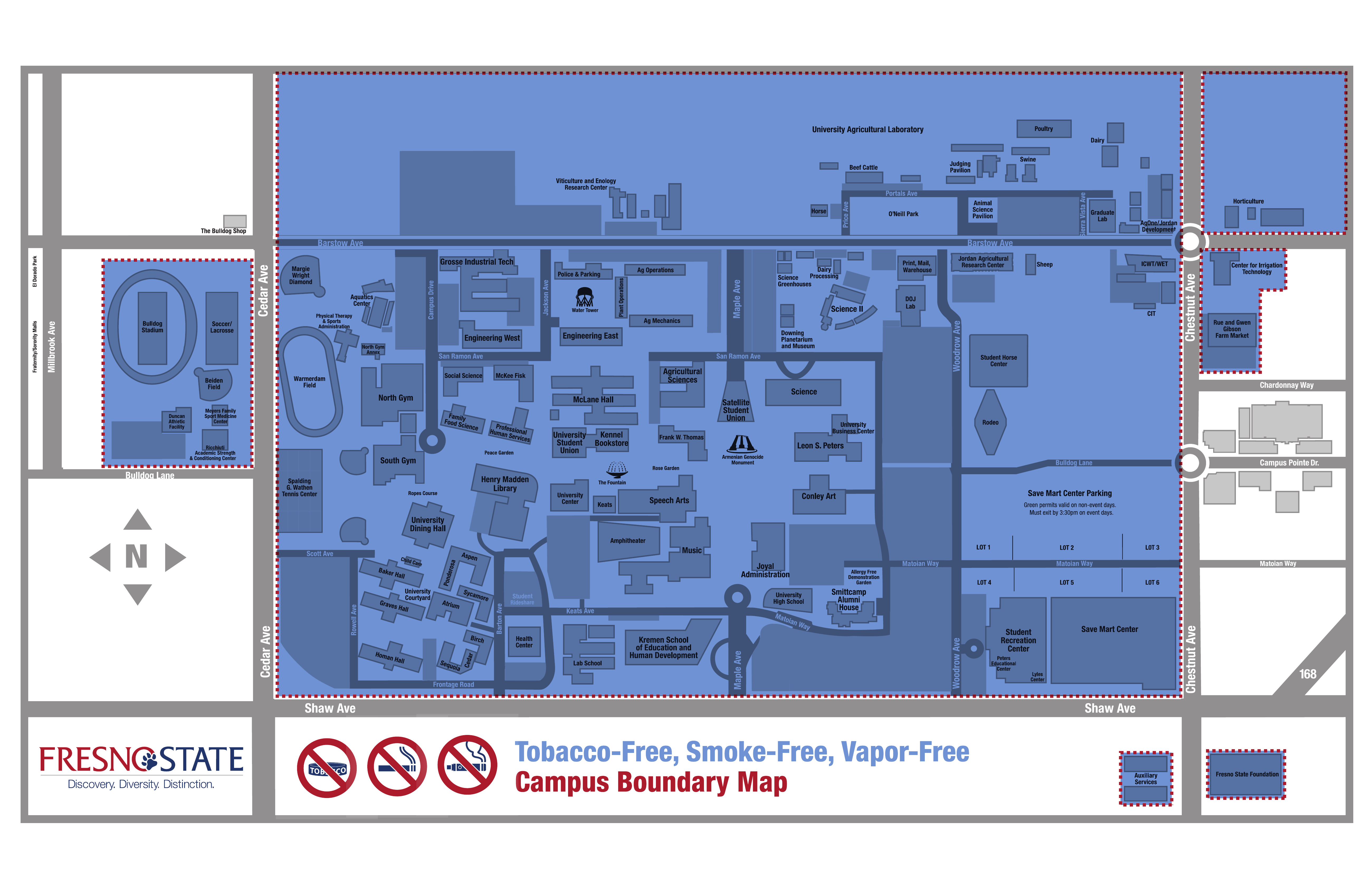
The map identifies the Fresno State areas shown as tobacco-free, smoke-free, and vapor-free. A text description of the marked areas and an index of labeled locations follow the map.
Boundary description
The map uses blue shading and a red dotted perimeter to identify the designated tobacco-free, smoke-free, vapor-free areas. The three prohibition symbols represent tobacco products, smoking, and vaping. The highlighted boundary includes a large main campus area and separate areas across nearby streets.
- Main campus and agricultural land
- The main highlighted area is east of Cedar Avenue, west of Chestnut Avenue, and north of Shaw Avenue. It includes the central academic campus, residence halls, recreation facilities, and the Save Mart Center. It continues north across Barstow Avenue through the University Agricultural Laboratory and Viticulture and Enology Research Center. The northern edge of this highlighted area is shown without a street name.
- Athletics complex west of Cedar Avenue
- A separate highlighted block lies west of Cedar Avenue and east of Millbrook Avenue, between the Barstow Avenue area and Bulldog Lane. It includes Bulldog Stadium, Soccer/Lacrosse, Beiden Field, Duncan Athletic Facility, Meyers Family Sport Medicine Center, and Ricchiuti Academic Strength & Conditioning Center.
- Horticulture east of Chestnut Avenue
- A separate highlighted area lies east of Chestnut Avenue and north of Barstow Avenue and contains the Horticulture facilities.
- Irrigation technology and farm market east of Chestnut Avenue
- A separate, irregularly shaped highlighted area lies east of Chestnut Avenue, south of Barstow Avenue, and north of Chardonnay Way. It includes the Center for Irrigation Technology and Rue and Gwen Gibson Farm Market.
- Auxiliary Services south of Shaw Avenue
- The Auxiliary Services building is shown in a separate highlighted box south of Shaw Avenue and west of Chestnut Avenue.
- Fresno State Foundation south of Shaw Avenue
- The Fresno State Foundation building is shown in a separate highlighted box south of Shaw Avenue and east of Chestnut Avenue.
Labeled locations within the boundary
Locations are grouped by their general position on the map. Building and facility names follow the labels in the supplied map.
North of Barstow Avenue
- University Agricultural Laboratory
- Viticulture and Enology Research Center
- Beef Cattle
- Horse
- Poultry
- Dairy
- Swine
- Judging Pavilion
- Animal Science Pavilion
- O’Neill Park
- Graduate Lab
- Ag One/Jordan Development
Athletics complex west of Cedar Avenue
- Bulldog Stadium
- Soccer/Lacrosse
- Beiden Field
- Duncan Athletic Facility
- Meyers Family Sport Medicine Center
- Ricchiuti Academic Strength & Conditioning Center
Western main campus: athletics and housing
- Margie Wright Diamond
- Aquatics Center
- Physical Therapy & Sports Administration
- North Gym Annex
- North Gym
- Warmerdam Field
- South Gym
- Spalding G. Wathen Tennis Center
- Ropes Course
- University Dining Hall
- Child Care
- Baker Hall
- Graves Hall
- Homan Hall
- University Courtyard
- Aspen
- Ponderosa
- Sycamore
- Atrium
- Birch
- Cedar
- Sequoia
- Student Rideshare
Engineering, agriculture, and science areas south of Barstow Avenue
- Grosse Industrial Tech.
- Engineering West
- Engineering East
- Police & Parking
- Water Tower
- Plant Operations
- Ag Operations
- Ag Mechanics
- Science Greenhouses
- Dairy Processing
- Science I
- Downing Planetarium and Museum
- Agricultural Sciences
- Science
- Satellite Student Union
- Print, Mail, Warehouse
- DOJ Lab
- Jordan Agricultural Research Center
- Sheep
- ICWT/WET
- CIT
- Student Horse Center
- Rodeo
Central and southern academic campus
- Social Science
- McKee Fisk
- Family Food Science
- Professional Human Services
- McLane Hall
- University Student Union
- Kennel Bookstore
- Peace Garden
- Henry Madden Library
- Frank W. Thomas
- Rose Garden
- The Fountain
- Armenian Genocide Monument
- University Center
- Keats
- Speech Arts
- Amphitheater
- Music
- University Business Center
- Leon S. Peters
- Conley Art
- Joyal Administration
- University High School
- Smittcamp Alumni House
- Allergy Free Demonstration Garden
- Health Center
- Lab School
- Kremen School of Education and Human Development
Southeastern main campus
- Save Mart Center
- Student Recreation Center
- Peters Educational Center
- Lyles Center
- Save Mart Center Parking
- Lots 1, 2, 3, 4, 5, and 6
Separate areas east of Chestnut Avenue and south of Shaw Avenue
- Horticulture
- Center for Irrigation Technology
- Rue and Gwen Gibson Farm Market
- Auxiliary Services
- Fresno State Foundation
Streets and orientation
North is up, east is to the right, south is down, and west is to the left. Cedar Avenue runs north–south along the west side of the main campus. Chestnut Avenue runs north–south along the east side. Shaw Avenue runs east–west along the south side. Barstow Avenue crosses the map east–west between the central campus and the agricultural area.
Other labeled streets and drives include Millbrook Avenue, Campus Drive, Jackson Avenue, Maple Avenue, Woodrow Avenue, Price Avenue, Portals Avenue, Sierra Vista Avenue, San Ramon Avenue, Bulldog Lane, Scott Avenue, Rowell Avenue, Barton Avenue, Keats Avenue, Matoian Way, Frontage Road, Chardonnay Way, and Campus Pointe Drive. State Route 168 is shown at the southeast edge of the map.
Parking note printed on the map
The Save Mart Center Parking label includes the following note: “Green permits valid on non-event days. Must exit by 3:30pm on event days.”
This HTML version was generated with AI assistance and may contain errors or omissions. The original approved PDF remains the official document of record. An alternative accessible format is available upon request from the document creator in accordance with Title II of the ADA.